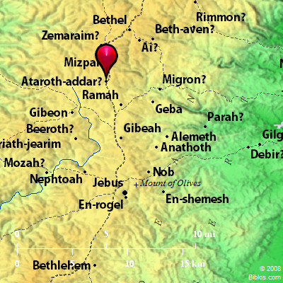
Atlas  Ataroth-addar and surrounding area
Maps Created using Biblemapper 3.0Additional data from OpenBible.info
You are free to use up to 50 Biblos coprighted maps (small or large) for your website or presentation. Please credit Biblos.com. Occurrences Joshua 16:5 This was the border of the children of Ephraim according to their families. The border of their inheritance eastward was Ataroth Addar, to Beth Horon the upper. Joshua 18:13 The border passed along from there to Luz, to the side of Luz (the same is Bethel), southward. The border went down to Ataroth Addar, by the mountain that lies on the south of Beth Horon the lower. Encyclopedia ATAROTHat'-a-roth, a-ta'-roth (`aTaroth, "crowns" or "wreaths"; Ataroth):
(1) A city East of the Jordan, apparently in the territory given to Reuben, but built, or fortified, by the children of Gad (Numbers 32:3, 34). It is named along with Dibon, which is identified with Dhiban. Eight miles Northeast by North of Dibon, on the South of Wady Zerqa Ma`in, stands Jebel `Attarus, in which the ancient name is preserved. The city is doubtless represented by Khirbet `Attarus, about 4 miles West of the mountain.
(2) A place on the boundary between Ephraim and Benjamin, toward the West (Joshua 16:2). It seems to be the same as Ataroth-addar of Joshua 16:5, 18:13. It is probably to be identified with the modern ed-Dariyeh South of nether Bethhoron, and about 12 1/2 miles West of Jerusalem.
(3) A place on the eastern frontier of Ephraim (Joshua 16:7). This town has not been identified. Conder thinks it may be identified with et-Truneh in the Jordan valley, or with Khirbet et-Taiyereh.
W. Ewing Strong's Hebrew H5853: Atroth Addara place on the border between Ephraim and Benjamin |
    |


