Atlas 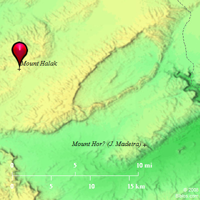 Mount Halak and surrounding area Maps Created using Biblemapper 3.0 Additional data from OpenBible.info You are free to use up to 50 Biblos coprighted maps (small or large) for your website or presentation. Please credit Biblos.com. Occurrences Joshua 11:17 from Mount Halak, that goes up to Seir, even to Baal Gad in the valley of Lebanon under Mount Hermon. He took all their kings, struck them, and put them to death.Joshua 12:7 These are the kings of the land whom Joshua and the children of Israel struck beyond the Jordan westward, from Baal Gad in the valley of Lebanon even to Mount Halak, that goes up to Seir. Joshua gave it to the tribes of Israel for a possession according to their divisions; Encyclopedia HALAK, MOUNTha'-lak (ha-har he-chalaq): A mountain that marked the southern limit of the conquests of Joshua (Joshua 11:17; Joshua 12:7). It is spoken of as the "mount Halak (literally, "the bare" or "smooth mountain") that goeth up to Seir." The latter passage locates it on the West of the Arabah. The southern boundary of the land is defined by the ascent of Akrabbim (Numbers 34:4 Joshua 15:3). This may with some certainty be identified with the pass known today as naqb es-Safa, "pass of the smooth rock," through which runs the road from the South to Hebron. To the Southwest opens Wady Maderah, a continuation of Wady el-Fiqrah, in which there rises a conspicuous hill, Jebel Maderah, composed of limestone, answering well the description of a bare or smooth mountain. It is a striking feature of the landscape viewed from all sides, and may well be the mount here referred to. |
    |